Met Éireann warns of more flooding with rain warnings in place
James Cox
Met Éireann is once again warning of localised and river flooding with difficult travelling conditions expected.
Another status yellow weather alert is in place for counties in the south and east of the country.
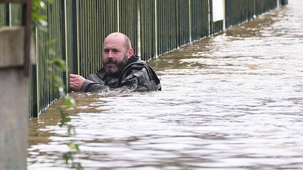
Flooding has been reported in many of these areas already this week, due to Storm Chandra.
This latest weather alert took effect at midnight - Carlow, Dublin, Kilkenny, Wexford, Wicklow and Waterford are under the rain alert until midnight tonight.

Met Éireann has warned that heavy rain, combined with saturated grounds and high river levels, could lead to more flooding.
Home owners and businesses across the east and south east are still counting the cost after being hit by significant flooding following Storm Chandra earlier in the week.
Several parts of Enniscorthy town centre were impassable on Tuesday with dozens of homes and businesses under several metres of water.

A Status Yellow rain warning has also been issued by the Met Office for Northern Ireland, from midnight until 6pm on Friday.
The latest alert comes as Minister for Housing, James Browne accused Met Éireann of holding back information on the severity of Storm Chandra.
Met Éireann forecaster Aoife Kealy has warned that “there is nowhere for the rain to go” which means more chances of localised flooding as more rain is expected to fall on ground that is already saturated.
Ms Kealy told Newstalk Breakfast that there will be a brief reprieve at the weekend, but there is more rain forecast for early next week.
There will also be further outbreaks of rain this morning with more persistent rain spreading from the south west through the afternoon and evening, she said.
“That rain, particularly later on today, is going to turn heavy at times. Now, of course, with the ground conditions as they are, we do have saturated soils and high river levels.
"That rain is just going to exacerbate any impacts that we've already seen over the last few days and particularly in those eastern and southern areas it's just going to add to those flooding impacts that we have already seen and even into tomorrow there will be further rain spreading up from the south which once again will turn heavy at times so there is that ongoing potential for flooding right through the rest of the working week."
Ms Kealy added: “There's simply nowhere else for the rain to go. The soils, as I said, are saturated and so any rain is just going straight to run off, straight into the rivers, and that's why we're seeing those impacts over the last few days.
"Even where accumulations aren't the highest, there will be some parts of the east and south that will maybe see a little less rainfall than those counties in the rainfall warning. There's still that chance of some localised flooding just due to those, those unfavourable ground conditions.”
The weather for the weekend is going to remain quite unsettled, she added.
“Low pressure will stay in charge of the weather. Now, over the weekend, there will potentially be some longer dry spells. Just a few patches of rain and drizzle early on Saturday, early on Sunday, and overnight Saturday night too. But it doesn't look likely that that will be quite as heavy as what we've seen. So there is potential for some drier weather there at the weekend.
"However, it is going to be short-lived. Next week there is a good signal for the unsettled trend to continue with high air with low pressure just continuing to drive that rain and those showers across the country.”

Irish Rail spokesperson Jane Creegan has been outlining the routes impacted by heavy rain.
Speaking on RTÉ radio’s Morning Ireland, Ms Creegan said there was subsidence on the line between Portmarnock and Malahide. “As a result of that, we've no Dart services operating between Malahide and Howth Junction. Dart Services are currently only operating between Howth, Howth Junction and Greystones and Bray.
“There's also a significant impact to Northern Commuter Services. We're operating a limited shuttle between Dundalk and Malahide, but then we have no service obviously between the affected areas. So, we are recommending for our customers that Dublin Bus and Go Ahead are honouring rail tickets, but you are going to expect significant delays and disruption to your journey into the city centre from that route this morning. “
Ms Creegan said that crews were on site attempting to deal with the tree that had fallen on the line as a result of subsidence.
“We're confident that we will have it cleared at some stage this morning but I can't give you a timeline on that and I suppose it'd be fair to say the morning peak will be affected by this.”
There are also issues with the Belfast line, she added. “We have flooding north of the border at Poyntzpass. So we have both transfers in operation between Newry and Belfast. We also now are endeavouring to get buses between Drogheda and the city centre on this side of the border. And we also have reduced frequency of services between Dublin and Belfast today. “
Work was ongoing to repair damage to signalling equipment in Enniscorthy and Ms Creegan was confident that a full service will return at some stage today.
“Currently we have bus transfers in operation between Gorey and Wexford, so again we just recommend everyone to check our website irishrail.ie and to follow us on social media for the latest updates.” - Additional reporting from Vivienne Clarke


