Emergency access points identified and mapped along the River Barrow
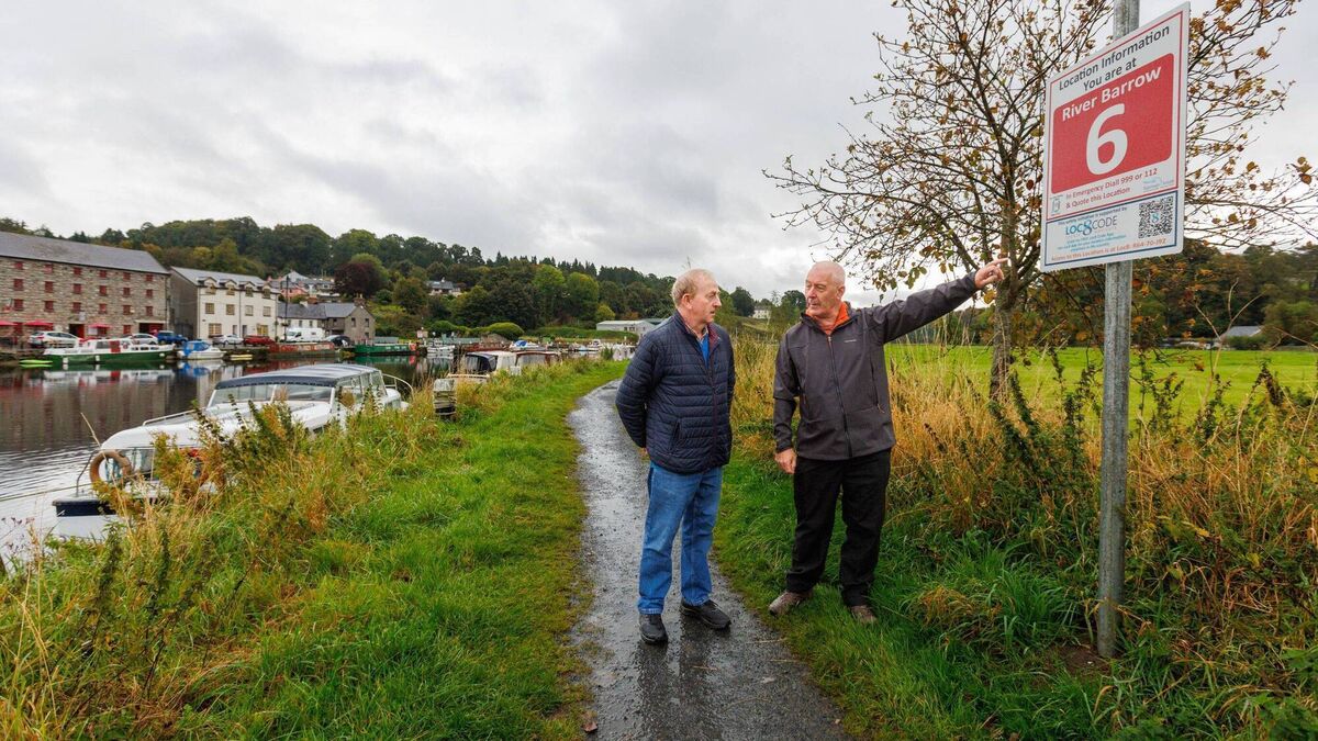
Christy Ward (right) and cllr Tommy Kinsella pictured in Graignamanagh beside one of the Emergency Access Signs located along the River Barrow, stretching from Athy in Kildare to St Mullins in Kilkenny Photo: michaelorourkephotography.ie
A SOUTH Carlow community first responder has been instrumental in the development of a new mapping system to guide emergency services to access points along the River Barrow.
Christy Ward has identified emergency access points along a 64km stretch of the River Barrow from St Mullins to Athy, allowing emergency services faster access in response to any incident along the river. The towpath or Barrow Track, as it is known, is unique in the sense that it runs the whole way from St Mullins to Athy and was used in olden days to transport goods by horse-drawn barge.
Christy, a regular walker along the Barrow Track, told The Nationalist how that concept came to him: “As a member of the emergency services myself, I could see that a system that all agencies could avail of would be very beneficial, especially in a time-critical situation.” Christy explained that an incident on the river can involve many agencies working together. “Gardaí, ambulance, fire service, coast guard, civil defence, sub-aqua teams and others work together in very difficult and dangerous conditions,” he said.
In 2020, he started to work on the projects with the help of Waterways Ireland and the different lock keepers along the route. He identified 34 locations that would be of benefit, which were then mapped by using a Point 8 Web App, www.loc8.ie/point8. Point 8 is a free app that gives a location anywhere in the country, helping to identify a location, especially in an emergency.
Christy then sent this information to the national emergency operations centre (NEOC), which has all Loc8 codes generated by Point 8 fully supported in its emergency response system.
“This particular project would not have been possible without the use of the Point 8 web app and the help, support and expertise I was given from the developer of this app, Gary Delaney from Loc8 Code,” he said.
Phase two of the project came when Waterways Ireland funded signage along the riverside. The signage is designed to give a location; for example, ‘River Barrow 12’. The emergency services can then use that location to identify the nearest emergency access point. Scanning a QR code on the bottom of the sign links to the Loc8 app, which can then provide an exact location between points, if needed. The signage is visible from both the river and the track, enabling people using the water to avail of it also.
“It is made from an illuminous material, enabling it to be read at night. It’s very important that when people avail of the great outdoors that they take the time to be aware of where they are and always have some plan in case of an emergency,” said Christy.
An official launch of this vital project is planned for spring 2025.
“I would like to thank the many people who were involved in this project since I started. It was truly a team effort and especially the individuals who have allowed the emergency services access through their private property,” concluded Christy.
Local representative Tommy Kinsella told The Nationalist it was a fantastic initiative.
“All the slipways from St Mullins to Athy have been numbered one to 40. If you’re anywhere along the line and you get into difficulty on land or on water, you’ll be able to contact emergency services, and they’ll immediately know where you are,” he said.
Christy is a regular user of the river and a first responder himself – he has seen the danger that people can get in to. “People will be able to be located very quickly and it can be expanded much further afield to include all, from fishermen to bikers and kayakers. I think it’s a great development,” he said.